Showing 48 items matching golf links
-
 Kew Historical Society Inc
Plan - Subdivision Plan, H C Crouch, Old Golf Links Estate, 1930s
... Old Golf Links Estate...Old Golf Links Estate...One part of a massive subdivision of the Old Golf Links...Annotations: "E" top left. "Golf Links" top right. Lots 73... Subdivision Plan Plan Old Golf Links Estate One part of a massive ...The land in North Kew between the Outer Circle Railway and the River Yarra was released in sections. This release included 80 lots. Most of this area was released during the Depression years in the early 1930s.Subdivision plans are historically important documents used as evidence of the growth of suburbs in Australia. They frequently provide information about when the land was sold on which a built structure was subsequently constructed as well as evidence relating to surveyors and real estate and financial agents. The numerous subdivision plans in the Kew Historical Society's collection represent working documents, ranging from the initial sketches made in planning a subdivision to printed plans on which auctioneers or agents listed the prices for which individual lots were sold. In a number of cases, the reverse of a subdivision plan in the collection includes a photograph of a house that was also for sale by the agent. These photographs provide significant heritage information relating house design and decoration, fencing and household gardens.One part of a massive subdivision of the Old Golf Links Estate in North Kew of 80 allotments bordering Sutherland Avenue, Ramsay Avenue, Belford Road, Beresford Street and Coleman Avenue. Inset on the plan at the top left, the route of the Outer Circle Railway is clearly marked. The Kew Golf Links is identified in its current location. The land on which Greenacres Golf Club was to be constructed is at this time marked as ‘Recreation Ground’. The ‘new bridge’ over the Yarra at Burke Road is also marked on the inset map. The Plan identifies the surveyor (sic) H.C. Crouch BCE MVIS, 443 Little Collins St., Melbourne. The date of the subdivision auction sale in identified as Saturday September 25th at three o'clock.Annotations: "E" top left. "Golf Links" top right. Lots 73-76 ticked and listed as "6" poundssubdivisions -- kew (vic.), old golf links estate -
 Lorne Historical Society
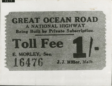
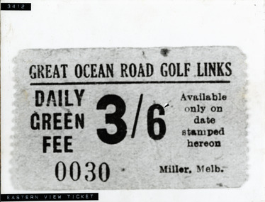
Photograph, Great Ocean Road Golf Links Ticket
... Great Ocean Road Golf Links Ticket...golf-links-ticket-3411: G.O.R; golf-link-ticket...Photograph of G.O.R. Golf Links Ticket numbered 3411... Road Golf Links Ticket Photograph of G.O.R. Golf Links Ticket ...Photograph of G.O.R. Golf Links Ticket numbered 3411golf-links-ticket-3411: g.o.r; golf-link-ticket -
 Kew Historical Society Inc
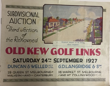
Booklet, Duncan & Weller Pty Ltd, Old Kew Golf Links Estate, 1927
... Old Kew Golf Links Estate, 1927...kew golf links estate...The booklet advertises the third sale within the Old Golf...Booklet Booklet Old Kew Golf Links Estate, 1927 6 page ...The booklet advertises the third sale within the Old Golf Links Estate which was a major subdivision of farmland in North Kew in the 1920sThe subdivision of the Kew Golf Links Estate was a major subdivision of farmland in Kew. The site was at one stage designated for industrial development and the building of a new Kodak factory. The decision by Council to oppose the redevelopment makes the beginning of the period when all industrial development was banned in Kew.6 page illustrated brochure advertising the third section of a major subdivision in Kew in 1927 including 75 charming home allotments and 7 valuable building sites. The brochure includes the subdivision plan. The front cover includes a colour illustration of the almost completed houses in Woolcock Avenue. Streets named include: Kilby Road, Kodak Avenue, Baker Avenue, Mathers Avenue, Coleman Avenue, White Avenue and Belford Road. Lots for sale are numbered. Existing buildings are designated with a square.subdivisions - kew (vic), kew golf links estate -
 Ringwood and District Historical Society
Photograph, Ice on trees in golf links. Location and Date unknown
... Ice on trees in golf links. Location and Date unknown...Written on back of photograph, "Ice on trees in golf links..., "Ice on trees in golf links". No mentioned on which golf links. ...Written on back of photograph, "Ice on trees in golf links". No mentioned on which golf links. -
 Kew Historical Society Inc
Booklet - Old Kew Golf Links Estate, 1926
... Old Kew Golf Links Estate...Old Kew Golf Links Estate... for sale in a subdivision called the 'Old Kew Golf Links Estate...Old Kew Golf Links Estate Booklet 8-page brochure ...Subdivision plans and real estate flyers/brochures reveal a number of aspects of urban development and history. The Kew Historical Society's collection of these plans, as well as advertisements extracted from magazines, cover key aspects of community development and architectural history of Kew and Kew Eat as well as surrounding suburbs. While most of the plans in the collection were gifted to the Society by the former City of Kew, a number of other plans and advertisements have been donated by individuals, of which this is an example.8-page brochure advertising 80 residential home sites for sale in a subdivision called the 'Old Kew Golf Links Estate'. These sites had historic importance in Kew's history as they had previously belonged to Kodak Pty Ltd who were refused permission by Kew Council to use the land for industrial development. The estate, advertised was advertised as being within five miles of Melbourne. The brochure is notable as it includes photographs of Kew East Primary School, the former Kew Golf Club clubhouse, and 'The Moorings' Boathouse (aka Chipperfield's Boat House). The aerial photograph, overlaid with names of notable sites, on the final page is of interest as it shows the area before the intrusion of the Eastern Freeway, which resulted in changing the course of a section of the Yarra River. old kew golf links estate, subdivision -- kew (vic.), subdivisions -- kew east (vic), chipperfield's boathouse, kew east primary school, kew golf club -
 Bayside Gallery - Bayside City Council Art & Heritage Collection
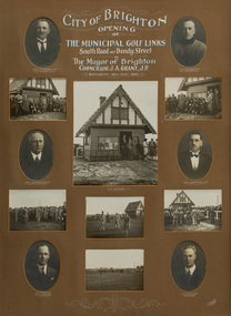
Photograph - gelatin silver photograph, H. Singer, Opening of The Municipal Golf Links, 1936
... Opening of The Municipal Golf Links...Brighton Municipal Golf Links... recording the opening of the Municipal Golf Links (now called... recording the opening of the Municipal Golf Links (now called ...golf, brighton municipal golf links, brighton public golf course, brighton east, mayor, councillor, opening, ceremony, speech, cr. j.a. grant, cr. e.m. young, cr. j.a. kennedy, cr. j. redapple, c.e. tuxen, city engineer, j.h. taylor, town clerk, kiosk -
 Kew Historical Society Inc
Plan - Subdivision Plan, Old Kew Golf Links Estate - Third Section, 1920-1929
... Old Kew Golf Links Estate - Third Section...old kew golf links estate - third section...When the old Kew Golf Links was subdivided in the mid 1920s... Subdivision Plan Plan Old Kew Golf Links Estate - Third Section When ...Pru Sanderson, in her groundbreaking ‘City of Kew Urban Conservation Study : Volume 2 - Development History’ (1988), summarised the periods of urban development and subdivisions of land in Kew. The periods that she identified included 1845-1880, 1880-1893, 1893-1921, 1921-1933, 1933-1943, and Post-War Development. These periods were selected as they represented periods of rapid growth or decline in urban development. An obvious starting point for Sanderson’s groupings involved population growth and the associated economic cycles. These cycles also highlighted urban expansion onto land that was predominantly rural, although in other cases it represented the decline and breakup of large estates. A number of the plans in the Kew Historical Society’s collection can also be found in other collections, such as those of the State Library of Victoria and the Boroondara Library Service. A number are however unique to the collection.The Kew Historical Society collection includes almost 100 subdivision plans pertaining to suburbs of the City of Melbourne. Most of these are of Kew, Kew East or Studley Park, although a smaller number are plans of Camberwell, Deepdene, Balwyn and Hawthorn. It is believed that the majority of the plans were gifted to the Society by persons connected with the real estate firm - J. R. Mathers and McMillan, 136 Cotham Road, Kew. The Plans in the collection are rarely in pristine form, being working plans on which the agent would write notes and record lots sold and the prices of these. The subdivision plans are historically significant examples of the growth of urban Melbourne from the beginning of the 20th Century up until the 1980s. A number of the plans are double-sided and often include a photograph on the reverse. A number of the latter are by noted photographers such as J.E. Barnes.When the old Kew Golf Links was subdivided in the mid 1920s, the developers were able to break the sale into sections. The third section included eighty lots. The lots faced Kilby Road, Kodak Avenue, Belford Road, Baker Avenue, Mathers Avenue, and White Avenue. [Kodak Avenue was renamed Page Avenue at a later date].The ‘Kew Conservation Study (1988) notes that ‘On the subdivision plan, Kodak’s involvement is commemorated by the naming of the streets after Company directors, and their decision to not proceed with the construction of the factory is explained as a response to the increase in the value of the land. This explanation may have been Estate Agent’s hyperbole, as the Kodak Company records suggest that the land, with its wide creek gully, was unsuitable and too small for its purposes.subdivision plans - kew, old kew golf links estate - third section -
 Lorne Historical Society
Photograph, G.O.R Golf Links green fee ticket
... G.O.R Golf Links green fee ticket... Road Golf Links...Photograph Photograph G.O.R Golf Links green fee ticket ...Photograph copy of Green fees ticket for the Great Ocean Road Golf Linksg.o.r-green-fees-ticket -
 St Kilda Historical Society
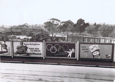
Photograph, View across Ormond Rd to St Kilda St and the Golf Links
... View across Ormond Rd to St Kilda St and the Golf Links...On back: View across Ormond Rd to St Kilda St & golf links... to St Kilda St and the Golf Links black and white photograph ...Shows advertising hoardings showing ads for Greater Hauling Power Ford OHV V8 Trucks, Tanox Paints, "let's paint for the Olympic Games", Craven A Virginia Cigarettes "They Never Vary"black and white photograph, unmounted, original, fair condition (small rip in corner)On back: View across Ormond Rd to St Kilda St & golf links -
 Kew Historical Society Inc
Plan - Subdivision Plan, Kew Golf Links Estate, 1936
... Kew Golf Links Estate, 1936...The Kew Golf Links Estate was a major subdivision in North... Golf Links Estate, to be auctioned on 7 November 1936. Streets...Subdivision Plan Plan Kew Golf Links Estate, 1936 ...The Kew Golf Links Estate was a major subdivision in North Kew. It derived its title due to the land being previously occupied by the Kew Golf Club, which transferred its course to a number of locations before occupying its current site. The Plan advertises 180 choice home sites. The street names are somewhat different today as those on the map are named after the proposed Kodak Factory to be built on the site. The subdivision of the Kew Golf Links Estate was a major subdivision of farmland in Kew. The site was at one stage designated for industrial development and the building of a new Kodak factory. The decision by Council to oppose the redevelopment makes the beginning of the period when all industrial development was banned in Kew.Monochrome printed, folded subdivision plan for the Kew Golf Links Estate, to be auctioned on 7 November 1936. Streets named include: Carnegie Avenue, Willsmere Road, Kilby Boulevarde, Kodak Avenue, Coleman Avenue, Beresford Avenue, McConchie Avenue, Cole Avenue, White Avenue, Baker Avenue, Spruzen Avenue, Tanner Avenue, Ratten Avenue, Mathers Avenue, Railway Avenue, Sutherland Avenue, and Belford Road. The position of the Yarra River and a large Drainage Reserve are marked on the plan. Lots for sale are numbered. Existing buildings are designated with a square.subdivision plans - kew (vic), kodak factory - kew (vic) -
 Lorne Historical Society
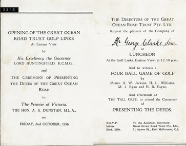
Photograph, Invitation to Luncheon opening G.O.R. Trust Golf Links
... Invitation to Luncheon opening G.O.R. Trust Golf Links...Invitation: G.O.R.-Trust-Golf-Links; The-Hon-A.A.Dunstan... to Luncheon opening G.O.R. Trust Golf Links Invitation dated Friday ...Invitation dated Friday October 2 1936 to Premier of Victoria The Hon A.A. Dunstan. His Excellency the Governor Lord Huntingfield for the ceremony of presenting the deeds of the G.O.R. invitation: g.o.r.-trust-golf-links; the-hon-a.a.dunstan: his-excellency-the-governer-lord-huntingfield; deeds-of-g.o.r. -
Canterbury History Group
Pamphlet - Camberwell Golf Links, c1932 original
... Camberwell Golf Links... of Camberwell Golf Links on Saturday 28 May c1932. Reproduced from... melbourne Camberwell Golf Links Pamphlet Brochure produced for Land ...Brochure produced for Land Sub-division sale by auction of Camberwell Golf Links on Saturday 28 May c1932. Reproduced from the original, includes Map and some historic photographscamberwell, fairmont avenue, camberwell road, christowell street, trams, vintage cars -
 Phillip Island and District Historical Society Inc.
Photograph, Early 1920's
... golf links san remo... with their golf clubs. Noted on back of photo "San Remo Golf Links...On back: San Remo Golf Links early 1920's... of photo "San Remo Golf Links". A question mark re location ...One of 5 photographs donated by Lyn Chambers & Frank Dominick - Wonthaggi Historical Society The following information was sent by a reader of VC for which we are very thankful. The golf course in San Remo was opened in 1922 and was on the land adjacent to Ocean Grove where Griffiths point lodge and Davis Point road now stand. One hole was placed on the flat land on the beach. There were red flags and the cows used to eat them. Black & White photograph of a group of people with their golf clubs. Noted on back of photo "San Remo Golf Links". A question mark re location as it seems too flat. Maybe it was in Cowes?? This has now been updated - see below under "Historical Information" 4/9/2016On back: San Remo Golf Links early 1920'sgolf links san remo, lyn chambers -
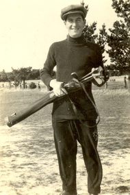 Federation University Historical Collection
Photograph - Black and White, Oliver Peacock, Frank Wright at the Ballarat Gold Links, 1921, 29/4/21
... ballarat golf links... Golf Links....Witten in pen on the back - Frank Wright, Ballarat Golf... Golf Links. Witten in pen on the back - Frank Wright, Ballarat ...Frank Wright was a renown resident of Smeaton, where he was born. He lived at Laura Villa, and attended Smeaton State School. His father William was a gold miner and his mother's name was Sarah. Their family won many singing and instrumental awards. Frank was tutored by Percy Code and was awarded a gold medal for the highest marks in the ALCM examinations in the British Colonies at the age of seventeen years. He became the Australian Open Cornet Champion by the age of eighteen. A year later, Frank conducted the City of Ballarat Band, and later the Ballarat Soldiers’ Memorial Band. He formed the Frank Wright Frisco Band and Frank Wright and his Coliseum Orchestra. These bands won many South Street awards, and Frank as conductor won many awards in the Australian Band Championship contest. In 1933 Frank Wright sailed to England to conduct the famous St Hilda’s Band and was later appointed Musical Director of the London County Council, where he organized many amazing concerts in parks, in and around the London district. He was made Professor of Brass and Military Band Scoring and conducted at the Guildhall of Music and Drama. Frank was often invited to adjudicate Brass Band Championships around Europe, in Australia, including South Street and in New Zealand. The Frank Wright Medal at the Royal South Street competition is awarded to an individual recognized as making an outstanding contribution to brass music in Australia.Black and white photograph of a man in a dark polo neck jumper and trousers wearing a cap and holding a set of golf clubs in a golf bag. The man is standing on patchy grass with a fence, paddock and trees in the background. The place is the Ballarat Golf Links.Witten in pen on the back - Frank Wright, Ballarat Golf Links, 29/4/21, Oliver Peacockfrank wright, ballarat, ballarat golf links, cornet, conductor -
 Ringwood and District Historical Society
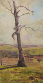
Painting, Winifred Miles, "Tree - East Ringwood Golf Links" - Oil on paper by Winifred Miles (1884-1944), Undated, later than 1910
... "Tree - East Ringwood Golf Links" - Oil on paper by... Golf Links" - Oil on paper by Winifred Miles (1884-1944 ..."Alexander Colquhoun [Herald art critic 1914-1922 and feature writer for the Age 1926-1941] ... took private students in the first decade of the century, and one of these was Winifred Miles, who after her marriage in 1910 lived the remainder of her life in Ringwood. ... (She) began by doing charcoal studies of animals when she was in Balranald, but in later years moved to oils and then watercolours, travelling around Ringwood to find places to paint by means of a pony-driven governess-cart. She won prizes for paintings in the Royal Melbourne Shows." - Hugh Anderson - Ringwood, Place of Many Eagles [p.217].Unframed painting with cardboard border. -
 Inverloch Historical Society
000598 - Photograph - 1954 - Leongatha - Golf Links under construction - from Welsford
... 000598 - Photograph - 1954 - Leongatha - Golf Links under...) Inverloch gippsland 000598 - Photograph - 1954 - Leongatha - Golf ... -
 Eltham District Historical Society Inc
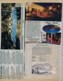
Newsclipping, 290 Mount Pleasant Road and Mays Park, 6 Mays Road, Eltham South, 1998 and Mulberry Hill, Golf Links Road, Baxter
... South, 1998 and Mulberry Hill, Golf Links Road, Baxter... Road, Eltham South, 1998 and Mulberry Hill, Golf Links Road ...Contained in Volume 2 of a set of two spiral magnetic photo albums, each containing 10 leaves, 20 pages; Vol. 1 labelled "Houses - Eltham South" and Vol. 2 labelled "Eltham Houses". Newspaper clippings promoting house auctionseltham, real estate advertisement, houses, baxter, mays park, mays road, mount pleasant road, mulberry hill -
 Eltham District Historical Society Inc
Photograph, Mulberry Hill, Golf Links Road, Baxter; Spring Excursion to The Briars and Mulberry Hill, 27 October 1991, 27/10/1991
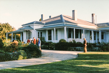
... Mulberry Hill, Golf Links Road, Baxter; Spring Excursion to... melbourne Photograph Mulberry Hill, Golf Links Road, Baxter; Spring ...[from EDHS Newsletter No. 80, September 1991:] SPRING EXCURSION: As usual for October we have arranged a bus tour outside the local area. We will leave from the Eltham Shire Offices at 9.00 am on Sunday 27th October and travel to "The Briars" at Mornington and "Mulberry Hill" at Baxter. The cost will be $16.00 for adults and $8.00 for children. This includes admission to each of the houses and afternoon tea at "Mulberry Hill". Bring your own lunch to eat at "The Briars" and something for morning tea if you wish. "The Briars" is one of the oldest pastoral stations on the Mornington Peninsula. It has historical associations with the early settlement of the district and with Alexander Balcombe who settled in the area about 1843. Near the house is a wetland wildlife reserve with walking paths and bird observation hides. "Mulberry Hill" was the home of Sir Darryl Lindsay and his wife Joan. Darryl (1889-1976) was a member of the famous art family of Lindsays and was a prominent artist in his own right. He was also a noted art administrator, being appointed Director of the National Gallery of Victoria in 1942. Joan Lindsay (1896-1984) was an important writer. Her best known work was "Picnic at Hanging Rock". Members may find it interesting to read her autobiography "Time Without Clocks" prior to this trip. Members are welcome to bring their friends. Bookings will only be confirmed on payment. Please complete the attached form and return with payment to the September meeting or to our post office box. The trip is still some time off but there is no further Newsletter before then. Note the date in your diary how. As this will probably be the first day of daylight saving you will need to remember that in organizing yourself on the day. Please arrive at 8.45 am ready for a prompt start at 9.00 am.Two colour photographsactivities, mulberry hill, the briars -
 Eltham District Historical Society Inc
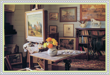
Postcard, Mulberry Hill, Interior, Golf Links Road, Baxter; National Trust postcard
... Mulberry Hill, Interior, Golf Links Road, Baxter; National... melbourne Postcard Mulberry Hill, Interior, Golf Links Road, Baxter ...Two colour photographs (postcards)activities, mulberry hill, the briars, postcards -
 Whitehorse Historical Society Inc.
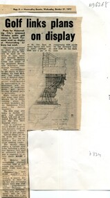
Article, Golf links plans on display, 1973
... Golf links plans on display... Mitcham melbourne Article Article Golf links plans on display ...Plans for the 145 acre South Vermont course between Morack Road and Dandenong Creek VermontPlans for the 145 acre South Vermont course between Morack Road and Dandenong Creek Vermont displayed at Nunawading LibraryPlans for the 145 acre South Vermont course between Morack Road and Dandenong Creek Vermontmorack golf course, south vermont -
Glenelg Shire Council Cultural Collection
Postcard, View of Portland, n.d
... in Bentinck St, Baths, Railway Pier, beach from Golf links...Front: 'Portland, from the Golf Links'. black script, lower... in Bentinck St, Baths, Railway Pier, beach from Golf links ...Black and white colour photo. View over Portland, taking in Bentinck St, Baths, Railway Pier, beach from Golf links on the commonFront: 'Portland, from the Golf Links'. black script, lower left corner Back: Handwritten message from 'Geoff' to Miss L Hollowood' - black ink -
 Peterborough History Group
Photograph - J S Irvine Memorial Photograph, David Scaletti, 1999
... Golf links... Peterborough Peterborough Golf Club Golf Golf links John Irvine Rod ...John S. Irvine was a resident of Peterborough and one of the original trustees of the present golf club. He died in 1999. Rod Calvert's house (on the corner of Blair & Schomberg) was used as the clubhouse, prior to the purchase of the current clubhouse.This photograph is significant for two reasons: it depicts the second hole plus some of the off shore rocks as they were in 1999. Mainly this is significant as John Irvine, along with N. R. Calvert, & P. G. Clark, guaranteed a loan in 1972 for the purchase of the land and building which are now the golf clubhouse. Until the Hall was built, this clubhouse was the meeting point for the community, and continues to be for many events. This photo was donated in his memory and in appreciation for his long service to the Peterborough Golf club24 inch x 40 inch framed photograph of the second hole, Peterborough and a framed photo of John S. IrvinePrinted title, photographers signature and copyright statement on the front. Plaque is inscribed: Donated in memory of John S. Irvine who helped create and loved this course and was a respected long serving member of this club.peterborough, peterborough golf club, golf, golf links, john irvine, rod calvert -
 Phillip Island Conservation Society Inc.
Work on paper - Photocopy of newspaper cutting, "On The Move/PENGUIN PARADE", circa 1960?
... golf links... Rocks Phillip Island koalas Governor Arthur Phillip golf links ...This article is written in a very conversational style with a number of asides and little 'digs' (e.g. Phillip Island being named after "Chap who first began to mess up Port Jackson".) The writer, Peter Fenton, is also relating some ornithological and tourist information, along with how to get to Phillip Island via the first Phillip Island bridge (so pre-1969) or train from Melbourne to Stony Point and across on ferry. The article is significant for demonstrating the growing interest in visiting destinations for natural experiences as well as activities such as golf and motor racing.photocopy of newspaper article cut from newspaper. double column of text with associated map below article. Dark patch from photocopy bottom right corner.15/3/65phillip island, little pengiuns, mutton birds, birds of the moon, pacific region, island rookeries, peter fenton, westernport ferry, stony point, railway line, first phillip island bridge, seal rocks, phillip island koalas, governor arthur phillip, golf links, motor racing course -
Canterbury History Group
Letter - Old Creeks of Canterbury, Caffin, Lyle, 26 Feruary 1990
... Golf Links Estate... Green Road Benporath> Mr Back Creek Gardiners Creek Golf Links ...Letter from Lyle Caffin to the Canterbury History Group describing childhood adventures at some of the local creeks.canterbury, creeks, trees, faversham road, winson green road, benporath> mr, back creek, gardiners creek, golf links estate -
Glen Eira Historical Society
Document - Reeves, Walter
... Football golf links... Road Rowney Dick Trams Riddell’s paddock Football golf links ...2 items, which may be related, about old Elsternwick: 1/A roneod copy of Recollections of Walter Reeves: gives notes on local identities, their business’, Caulfield State School, places of interest and events that took place in the area; undated and apparently summarised by an un-named other person from Mr Reeves' recollections. 2/A hand written list taken from Rate Books 1864 of areas in dispute, including nine names of residents, between Caulfield and St Kilda, date and author unknown. No direct connection to Walter Reeves apparent but they are taped together.automobile, hebenstreit mr, shoobra road, butcher, glenhuntly road, henderson h mr, davis charles, hardware store, beddoe frank, horne street, shops, renown theatre, phoebe theatre, theatres, lepage phoebe, lepage jack, taylor ‘squizzie’, echuca terrace, edward street, hawthorn road, revees walter, dunn bros, cycle shop, cox bros, supermarkets, apps (undertakers), elsternwick men’s club, elsternwick trades club, johnston t., hayter george (painter and decorator), sargood frederick, cabmen, cabs, ‘ripponlea’, wilson dick, blacksmiths, orrong road, moran and cato, repco, downshire road, bullock (grocer), grocers, taylor’s liquor and wine saloon, bottleshops, biddle misses, schools, bliss mr, station master, elsternwick, bensonino mr, newsagents, caulfield, gas supply, point nepean road, rowney dick, trams, riddell’s paddock, football golf links, riddell john carre, rowan road, sports grounds, melville’s supermarket -
 Kew Historical Society Inc
Photograph - Yarra Flats near Burke Road Bridge, 1937
... open space, parkland or public golf links. By the 1930s much... either designated open space, parkland or public golf links ...Land along the Yarra River in Kew is now either designated open space, parkland or public golf links. By the 1930s much of this area remained open farmland, bought at auction for dairy farming in the 1840s.Original, black and white positive print of what is said to be the Yarra Flats near Burke Road Bridge. On the horizon, building can be seen, whereas in the middle ground, farm fencing and a windmill are the main features as well as remnant Eucalypts. Inscribed verso: "Yarra Flats near Burke Rd Bridge 1937" studley park -- kew (vic.) -
Glenelg Shire Council Cultural Collection
Newspaper - Newspaper - Weekly Times 1921, The Weekly Times, 07/05/1921
... and new pier, golf links, bathing beach and Battery Point. Photos...., Lighthouse Bluff, baths and new pier, golf links, bathing beach ...Page from 'The Weekly Times' of 7 May 1921. Seven black and white photographs of Portland: golfers, croquet lawns, panorama from Battery Point, Bentinck St., Lighthouse Bluff, baths and new pier, golf links, bathing beach and Battery Point. Photos of Victorian State Schools nursery at Oakleigh on reverse.weekly times, newspaper, tourism, visitor, recreation leisure, portland, portland harbour -
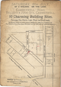 Kew Historical Society Inc
Plan - Subdivision Plan, 10 Charming Building Sites, 1930-1940
... weatherboard and ‘Rough Cast’ villas. The old Golf Links are identified...’ villas. The old Golf Links are identified at the rear ...This subdivision plan shows 10 lots, numbered A-J, that were offered for sale in Camberwell. Streets in the subdivision include Camberwell Road, Judd Street, Bellett Street and King Street. The plan lists existing houses in the vicinity including weatherboard and ‘Rough Cast’ villas. The old Golf Links are identified at the rear of the Bellett Street lots.subdivision plans -- camberwell (vic.) -
Kew Historical Society Inc
Booklet - Yarraleen Estate, Bulleen, c.1966
... development, photographs of key facilities (Marcellin College, Golf... (Marcellin College, Golf links, local swimming holes, the Beaver Swim ...Subdivision plans and real estate flyers/brochures reveal a number of aspects of urban development and history. The Kew Historical Society's collection of these plans, as well as advertisements extracted from magazines, cover key aspects of community development and architectural history of Kew and Kew Eat as well as surrounding suburbs. While most of the plans in the collection were gifted to the Society by the former City of Kew, a number of other plans and advertisements have been donated by individuals, of which this is an example.Original 8-page booklet advertising a new residential development in Bulleen entitled 'Yarraleen'. The glossy multi-colour brochure includes historic and contemporary photographs of the Yarra Valley, graphic designs of potential residential development, photographs of key facilities (Marcellin College, Golf links, local swimming holes, the Beaver Swim School, Carey Grammar School Oval and grandstand, shopping strips, and farmland).subdivisions -- bulleen (vic.), yarraleen estate -
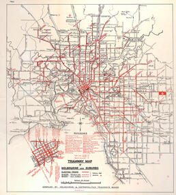 Melbourne Tram Museum
Map, "Tramway Map of Melbourne and Suburbs", c1950
... , all-night bus routes, depots, golf links and sporting grounds... routes, depots, golf links and sporting grounds, rail lines ...Map of Melbourne's Tram and Bus routes, route destinations, all-night bus routes, depots, golf links and sporting grounds, rail lines, and location of major places of interest. Titled - "Tramway Map of Melbourne and Suburbs" - c1950, after the La Trobe or Latrobe St lines opened. Not known who produced the map. Does not give route numbers. See also Reg Item 2300 for an MMTB Map of the same era, 3720 for a similar version with the MMTB guest houses shown, and 4525.1 for an MMTB Photograph.Yields information about Melbourne tram routes prior to Bourke St being built.Fold out map (6 sections), two colours. Has been removed from a book with the remnants of other paper in the top left-hand side.has "1950" in top left hand corner in ink.trams, tramways, melbourne, map, tram & bus services, all night services, mmtb